 |
 |
 |
Visualizing Real-Estate with up-to-date Aerial Photos, "Satellite" Views and 3D Image Models Create Using DronesMike Heath (LaunchedPix@heathphotographyonline.com)Fletcher Heath (heath.uas@gmail.com) Heath Aerial Imaging Rochester New York December 28, 2020 |
Drones applied to this application are small unmanned aerial vehicles, equipped with cameras and GPS that are remotely piloted by an operator on the ground. The sky-based view they provide allows one to visualize how land is being used, what structures are on it and how the property fits into its surroundings.
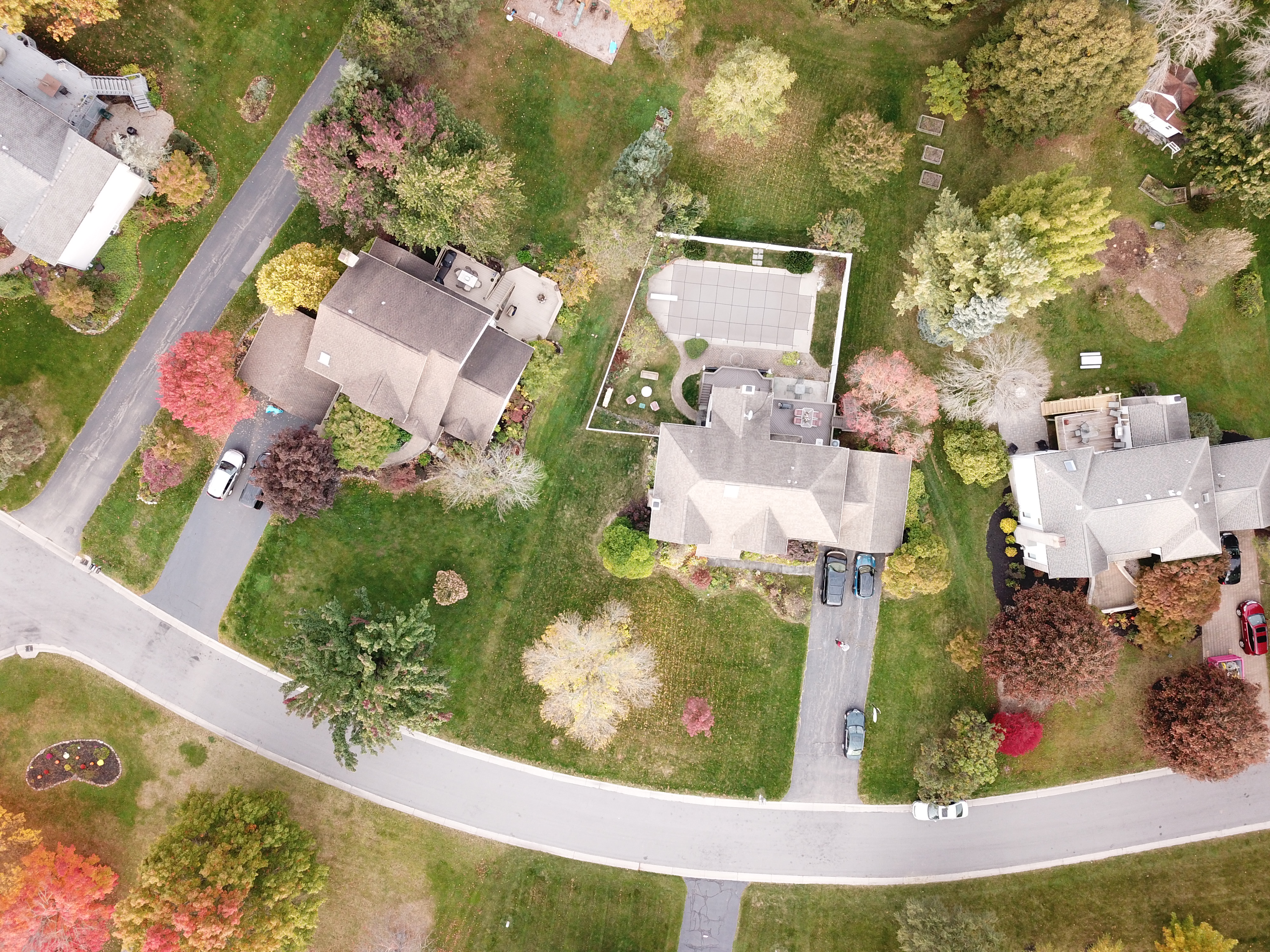
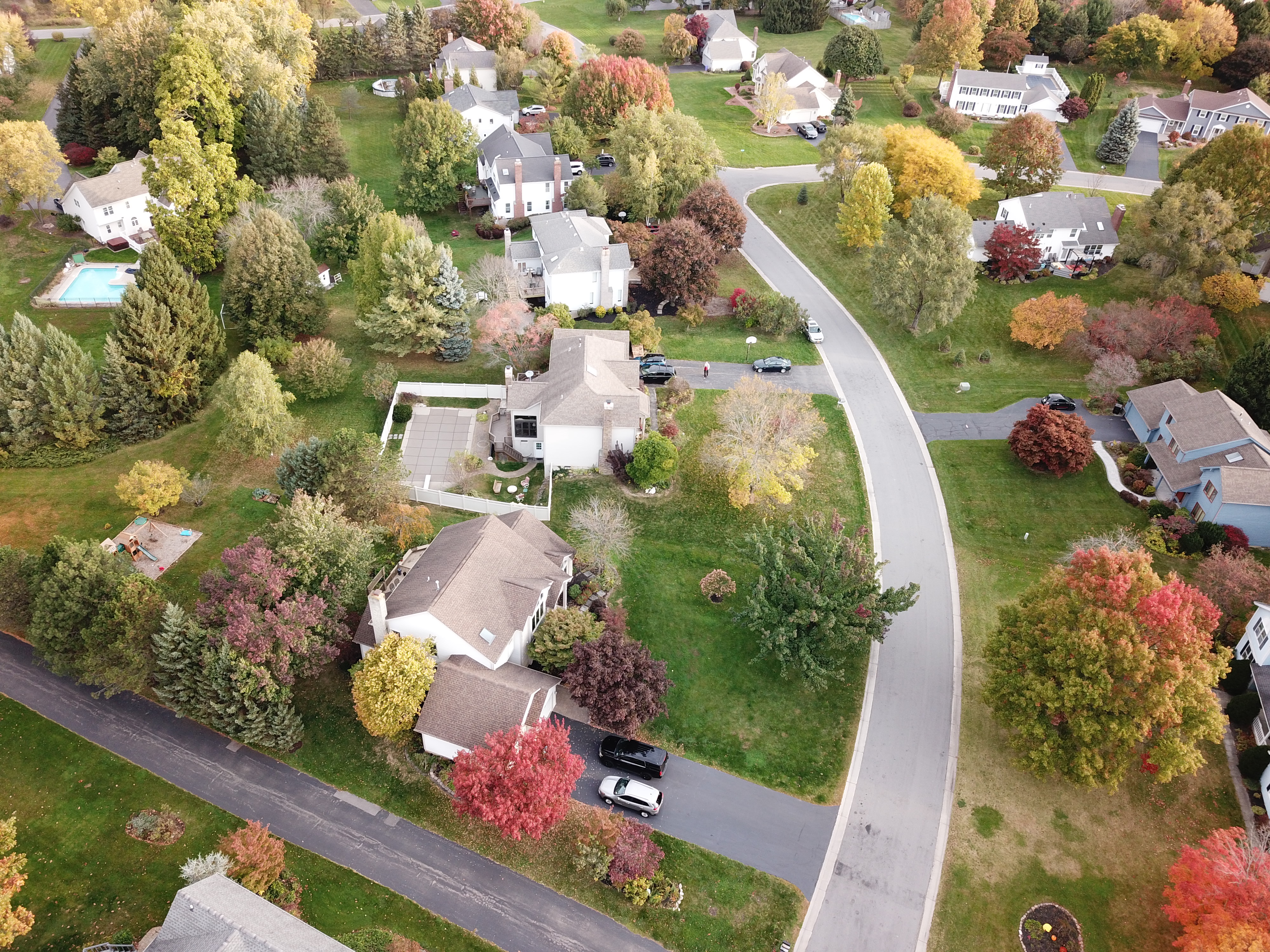
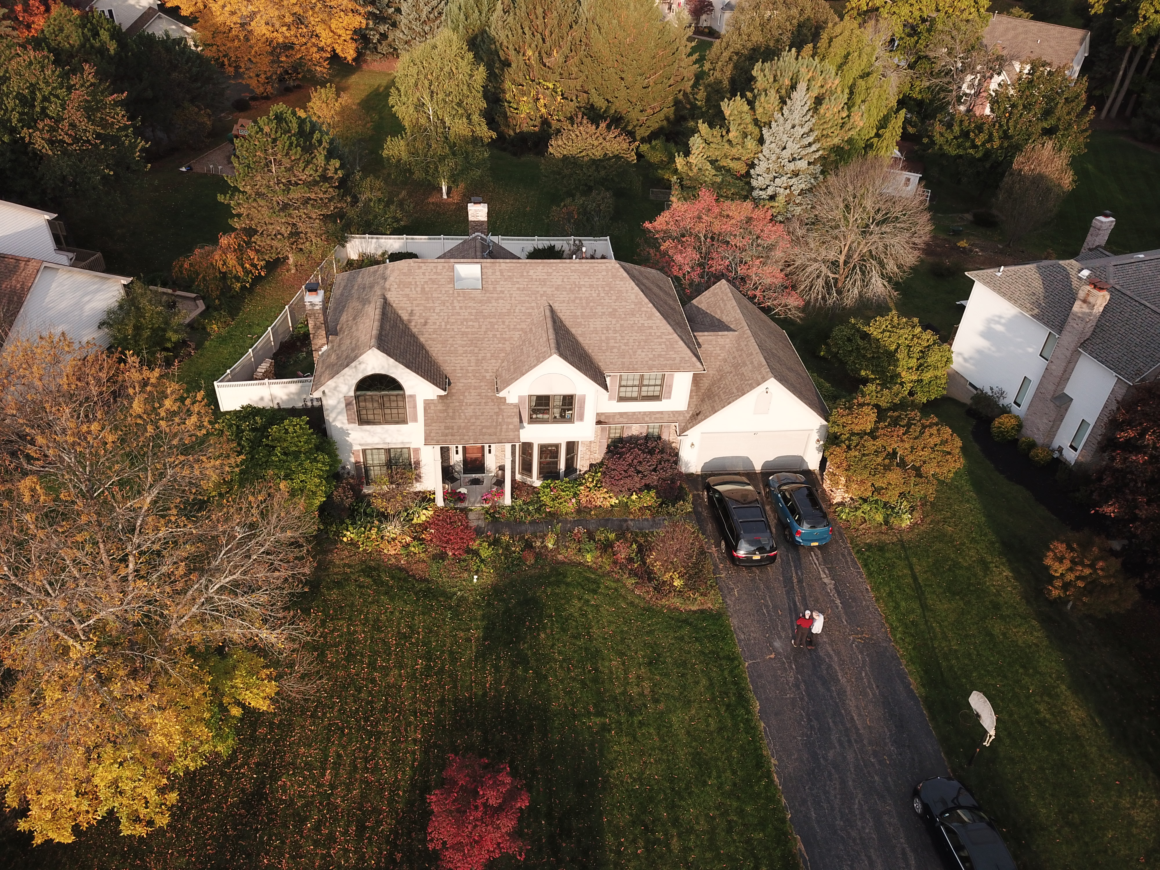
The drone photos in Figure 1 show a house and a section of the neighborhood where it is located. These were captured in October of 2020 with a DJI Mavic Pro drone. The photo in Figure 1a shows the central house and captures all of the 0.47 acre property. The side view in Figure 1b shows additional details about the house such as the properties elevation drop of the back yard and how the house was built with a walk-out basement to take advantage of that land feature. The front view in Figure 1c shows the covered front entranceway and privacy in the back yard provided by the thick tall trees.
Its more challenging to capture views like these of larger properties using drones. The Federal Aviation Administration (FAA) limits their maximum flight altitude to 400 feet above ground level so its not always possible to fit an entire property into one photo. Such properties require flying a drone to capture many images and then processing them with a computer to stitch them together. When done properly, this process can produce a straight down looking view of a large property as well as a 3D model that can be viewed on a computer from any angle. The straight down looking image is called an orthomosaic photo. Both orthomosaic photos and 3D models can be viewed using Google Maps so these imaging products will be described first with the aid of Google Maps.
|
|
|
Google Maps also offers an additional view of some areas that can be manipulated interactively to virtually fly above it. These views come from 3D models that are prepared from overlapping aircraft imagery using a process called photogrammerty. The 3D models are detailed enough to see trees, buildings and larger terrain topography. A short video titled Google Earth's Incredible 3D Imagergy, Explained" provides an overview of Googles imagery of the earth, the 3D models and how they are created.
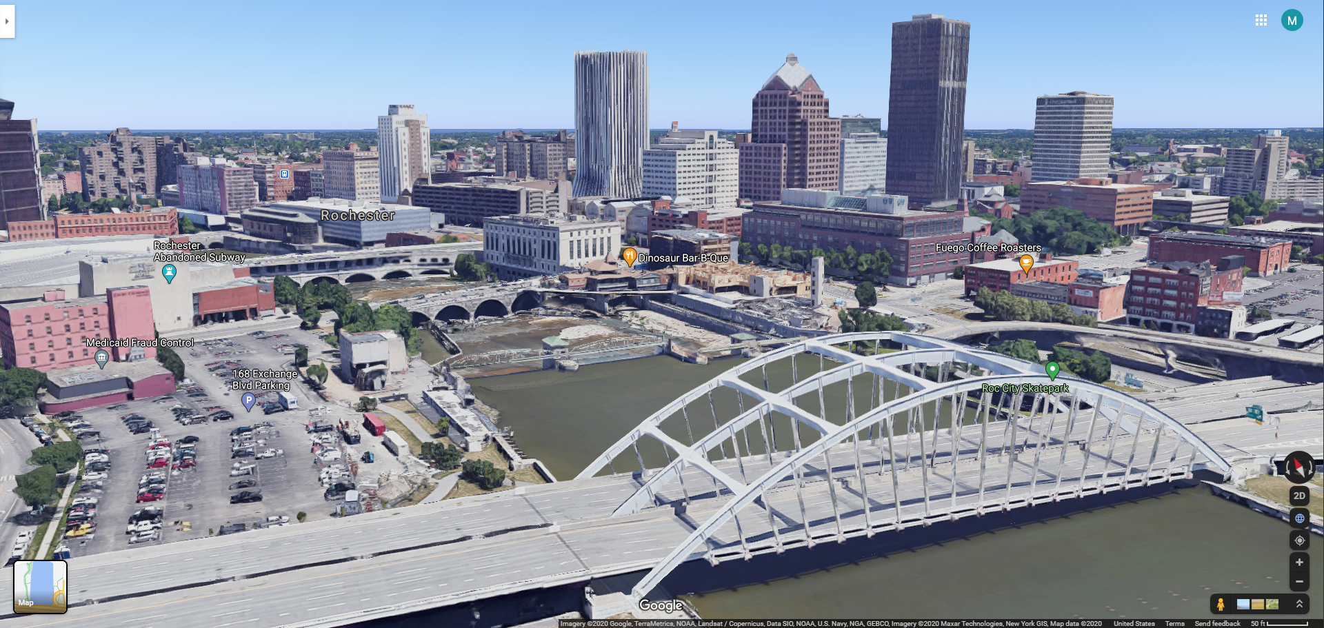
A great way to understand the power 3D data is simply to start viewing it. The image to the right in Figure 2 shows a view of a well-known location in downtown Rochester, New York. The picture is a static screen-shot of a 3D view but a link is provided below it to interactively view the area from any vantage point using Google Maps.
|
As impressive as Google Maps 3D view is, it has two principle limitations. The first is data availablility (both where and when the images were captured) and the second is the the amount of detail visible in the models. You can check if 3D data is available in your area using Google Earths Voyager layer.
We are fortunate that 3D data is available in our home area of Monroe County New York. It covers quite a large area. At the edge of the county there is a boundary where the 3D data ends. Here the terrain flattens out, appearing as if a giant squished the trees and buildings to the ground. The image in (Figure 3) illustrates this 3D to 2D data transition.
|
This article will show how drone imaging can be used to fill in the gaps in Google Maps 3D coverage and to provide a up-to-date, interactive, high resolution 3D visualization of realestate.
Advanced drone flight capture and photogrammerty processing techniques can be applied to take many (sometimes hundreds of) images and turn them into both orthomosaic (map-like, straight down looking view) images and 3D textured digital models. Essentially, these methods provide a means to create the 2D and 3D style of views that are available in Google Maps.
Figure 4a shows an orthomosaic photo and Figure 4b shows a short movie clip of a computer generated view of a 3D model created from drone imaging. In this case both were created by processing about 200 drone photos.
Drone imaging can also provide highly detailed 3D models. This requires flying lower to the ground and taking a lot more photos. Figure 5 shows two computer generated images of a house. The image in Figure 5a was created from the Google Maps 3D viewer and the image in Figure 5b was created from a 3D model aquired by drone imaging. The drone image looks more photo realistic. This is because the drone captured images from a much closer vantage point than the aircraft used by Google to capture images for its 3D model. While this example emphasizes the capability of the drone for capturing high detail, the capture of images by aircraft is advantaged for creating models of large regions. The effectiveness of drones diminishes as an area gets larger. Most smaller commercial sized drones are best suited for imaging an area up to about 100 acres.
 (a) A section of an orthomosaic photo created from drone images. It shows a top-down view of a section of a neighborhood that cannot be obtained in a single photo by a drone operating below the FAA imposed maximum operating altitude of 400 feet (AGL). Click here to view the full image (29MB)in a new tab. Click within that image (in the new tab) to toggle a full-resoltion view of it. |
(b) A video showing a rotating house that appears to be a movie captured by a drone in flight. The video was actually generated by a computer from a 3D model that was created from drone images. This demonstrates how a property can be viewed from different angles once it has been captured as a 3D model. Instructions will be provided later in the article to view the 3D model using a web-browser and a computer. |
 (a) A 3D view of a house in Google Maps. |
 (b) A 3D view of a house created from drone images. |
Thus far, the 3D models that were created by drones have only been presented as static 2D screen shot images and a short computer generated movie. Having a 3D model is useless without a way to visualize and share it. Sharing a images is commonplace today. Most everyone captures, views and shares images every day. Sharing 3D models isn't so easy. Most people wouldn't know how to view them and would believe they can only do it with a high-end computer using expensive software. Fortunately that is no-longer the case.
There are many commercial and free software packages available for viewing 3D data on nearly any computer: Meshmixer and Blender are two examples. These software packages can be downloaded and installed on a computer both to view and edit 3D models. They provide a lot of capabilities but can, unfortunately, require a steep learning curve to use them effectively.
Another option to view models may be more beneficial to new users. It runs within a web browser and does not require the installation of any software. This is the Sandbox web viewer from Babylon.js. It can be accessed via a web browser with the link https://sandbox.babylonjs.com.
The 3D models that are provided in this article (on this web-page) can be saved to your computer with the click of your mouse and can then be dropped into BabylonJS for viewing.
A video series by Babylon.js on YouTube can teach you some extra viewing options via their Inspector to get the most out of your model. Instructions describe how to change things like the model shading and the cameras field of view. The inspector also provides tools for capturing photos and videos of your displayed 3D models. The video in Figure 4b was created using the Inspector in Babylon.js Sandbox viewer.
If you would like to interactively view the 3D model of the house you can easily download it and view it in the Babylon.js viewer. Just click here to download the 3D model (137MB), click here to open the BabylonJS window in a new tab, and then drag/drop the model you downloaded into that web viewer window.
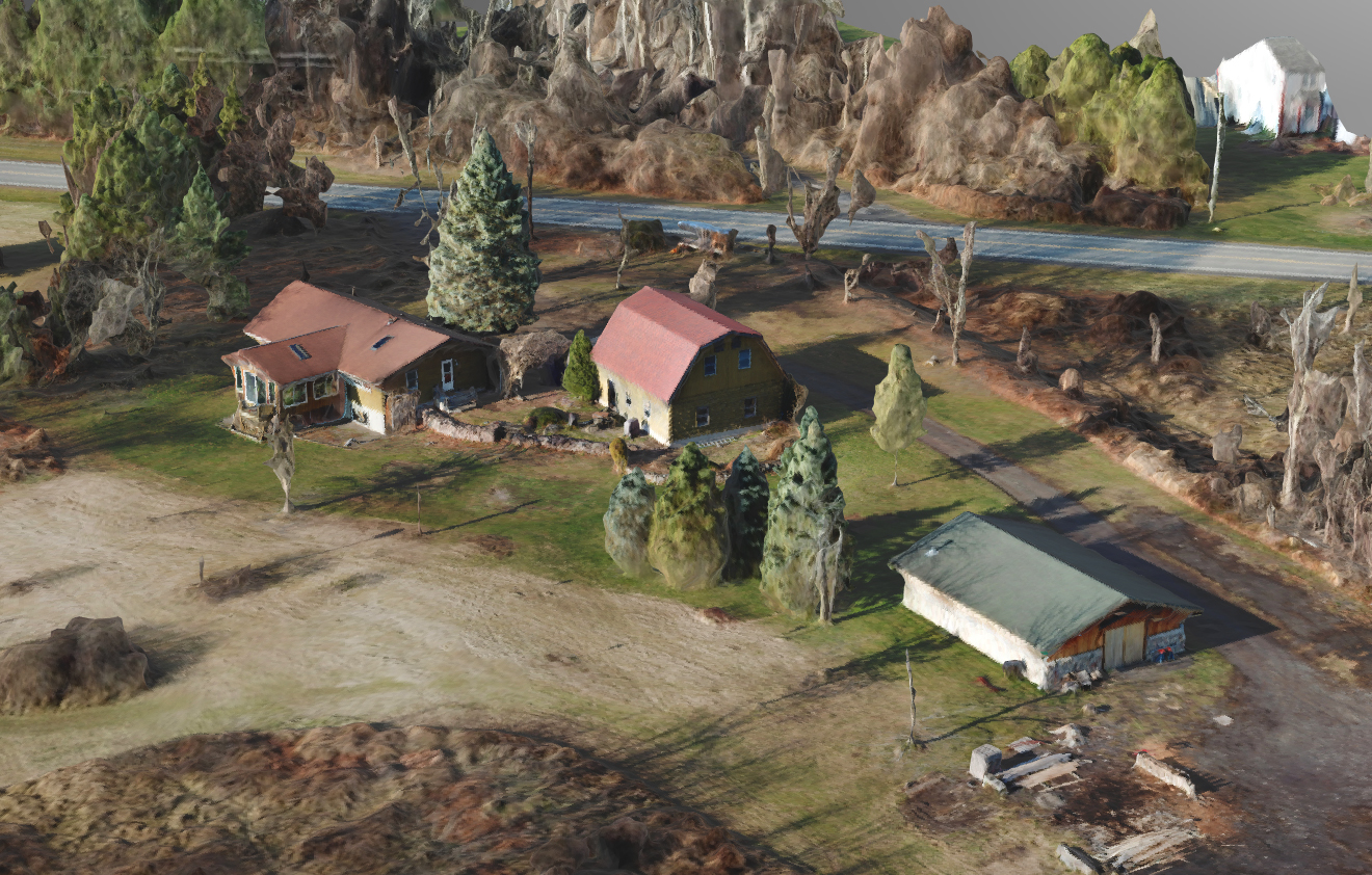
The property in Figure 2 that is just outside of the area covered by Googles 3D imaging of Monroe County New York was images using a drone. Flights were made in December 2020 using a Mavic Pro drone. The property is 4.31 acres and it was imaged within a surrounding area covering nearly 15 acres. A total of 457 photos were taken during 40 minutes of flight time. This required landing the drone part way through imaging to change the drone battery. These photos were distributed between a 2D crossgrid flight, three circular "orbit" flights and an additional manual flight that was performed to acquire close-up images around the buildings. Figure 6 shows a plot of the camera locations from which the photos were taken.
 |
The set of images provide detailed pictures of the entire property, but viewing them does not provide a clear understanding of the layout of the property. Its hard to present all of the image data here as it is about 2.3GB of imagery. If pasted together into a poster, the images would be 5240 megapixels. A small (1/10th size) image is provided in Figure 7 that is displayed here at an even more reduced size. Click on the image to bring up the full 1/10th size image and then vlick in it to view the full 1/10 scale. The simple point of this is that its very difficult to interpret the layout of the property from the photos.
The images were processed using DroneDeploy software. This software output an orthomosaic photo and a 3D model in Wavefront (.obj) format. The 3D model was then converted to GLTF format and was then displayed in BabylonJS. Figure 8 shows that orthomosaic and two screen captures of the model as displayed in BabylonJS.
The 3D model can be downloaded by clicking here (176MB). That model can then be viewed in BabylonJS. To view the downloaded model just drag it into the BabylonJS viewer.
 |
 |
 |
 |
Take AwaysDrones provides a way to capture up-to-date aerial images and capture data to create orthomosaic images and 3D models. Better ground resolution can be provided from drones that from aircraft and satellites though drone imaging with smaller commercial drones is best applied to imaging areas that are less than 100 acres. If you are interested in having your propery imaged with this technology, look for an experienced, insured, FAA Part 107 certified drone mapping service provider in your area. This article resides at http://heathphotographyonline.com/LaunchedPix/DroneRealEstateImaging/3DRealEstateImagingUsingDrones.html. It is best viewed from this location as that is where all of the supporting images, video and 3D models reside. |